Notes on geography
Georgia counties in Cherokee territory
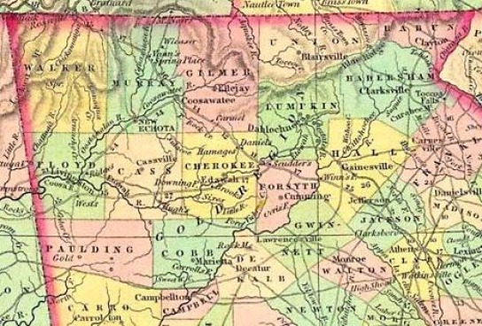
Cherokee County was the name originally given for all the Cherokee Nation illegally stolen from the Cherokees in 1828. It was formed on 26 December 1831, but never functioned as a formal county. On 3 December 1832, the legislature added portions of Habersham and Hall Counties to Cherokee, and divided it up into 10 counties -- Cass, Cherokee, Cobb, Floyd, Forsyth, Gilmer, Lumpkin, Murray, Paulding, and Union. (Ga. Laws 1832, p. 56).These 10 counties were further subdivided into smaller counties (Georgia has more than any other state except Texas). Portions of the smaller Cherokee County became Pickens, Milton, Cass, Cobb, and Forsyth Counties.Pickens County was formed in 1853 from portions of Gilmer and Cherokee Counties. The majority of its territory was originally in Gilmer, including the Talking Rock and Truck Wheel Districts.Cass County was renamed Bartow County in 1861. Portions of it were used to create Gordon County in 1850, although the bulk of Gordon came from Murray.Murray County originally comprised the entire northwest corner of Georgia from just south of Calhoun east to the present Gordon County border and north to the Tennessee line. Portions of it later became Catoosa, Chattooga, Floyd, Gordon, Walker, and Whitfield Counties.
The Old Federal Road
The Old Federal Road can be seen on this map running from Athens, Georgia to Ross Landing (Chattanooga).
Gordon County, Georgia
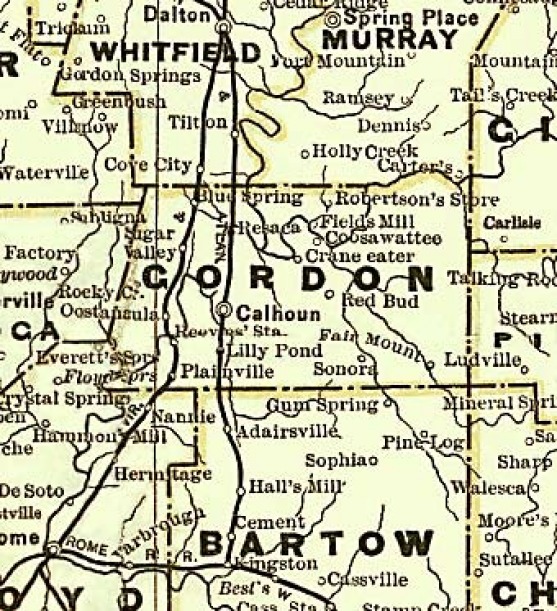
Everett Springs Road in Gordon County is State Highway 136 today, but no doubt it followed a different route originally. As the 1883 map above shows, and at least as late as 1904, maps of Gordon County showed only two main roads, one from Cartersville through Adairsville to Dalton, and the other from Rome tthrough Plainville, Reeves Station, Oostanaula, and Sugar Valley to Dalton. As the photos below suggest, the Rome to Dalton road used to follow the railroad, and it remains intact from Sugar Valley to Oostanaula, but the section from Oostanaula to Plainville through Reeves Station has been abandoned.
Because of the huge Oostanaula Bend in western Gordon County, Highway 136 swings due north to avoid it, and it intersects with the Rome-Dalton road above the community of Oostanaula. But there is no “there” there. That is, there is no community where 156 crosses the river, which leads me to speculate that the original Everett Springs Road may have ended in Oostanaula. In the 1910 census, Annie Hall and her children are living on Everett Springs Road in the Oostanaula District as is George W. Hall. His home is at or near Todd’s Mill Road, but there is no Todd’s Mill Road today.
I think the Oostanaula-Calhoun Road referred to in the census records crossed the river via ferry or ford due east of Oostanaula and connected to what is today Harris Beamer Road. In the 1930 census, Jasper Hall’s son Sherman is living on the Oostanaula-Calhoun Road, but no such road any longer exists.
Harris Beamer begins in the outskirts of Calhoun at the Highway 53 Spur and goes almost directly westward until it gets within a quarter-mile of the river, then abruptly turns north to connect with Highway 136.
Newton Jasper Hall, as noted earlier, is buried with Annie on Harris Beamer Road, a half-mile or so from this bend.
Halls Station, Bartow County
Halls Station is a small community located five miles due south of Adairsville, Georgia, on the Halls Station Road (See map above). It was named for L. H. Hall, an agent for the Western and Atlantic Railroad. It has also been known as Halls, Hall's Mill, and Linwood. The Connesena Baptist Church is located two miles south of Halls Station on Connesena Church Road. Members of the Smith, Carnes, and Brownlow families lived in this area.
McGuire's Store, Floyd County
McGuire's Store was the name of a post office established in northern Floyd County in 1852, in what would later be the Watters Dictrict. McGuire's Store was located near the junction of Highways 53 and 140. The old intersection is just north of the present one, where the Plainville Road (Old 53) forks off to the west. Another name for McGuire's Store was "Nannie," which is on the map above. Shannon (Hermitage) about two miles south of this intersection, is the only town in the district now. Several families of relatives lived in this district.
Source of map:
http://georgiainfo.galileo.usg.edu/histcountymaps/gordon1899map.htm


The top photo was taken in Oostanaula, Georgia looking south, and the bottom photo taken in Reeves Station looking north. Both show the same railroad bridge over the Oostanaula River. I believe this is the path of the original road from Rome to Dalton.
Pickens County, Georgia

This map, from 1899, shows the locations of Ludville, Hinton, Blaine (the original site of Talking Rock), and Talking Rock in Pickens County, as well as Ryo and Fairmount in Gordon, Salacoa in Cherokee, and Pine Log, Cass, and Cartersville in Bartow. Members of the Collins, Hall, and Smith families lived in this area in the 19th century.
This map also shows a community called "Scearcorn" a short distance northeast of Blaine on what is today Swan Bridge Road. This entire cornerof Pickens County was called the Scared Corn circuit by the Methodists, and the church and campground at Hinton were referred to as the "Skeerd Corn Church." Supposedly, the names are derived from Scarecorn Creek, which begins south of Talking Rock and flows into Talking Rock Creek west of Highway 136 a mile or so northwest of Blaine. But the community of Scearcorn is a mystery. Scare Corn Creek does not flow anywhere near it, and it is only present on this one map. There is no reference to it in the History of Pickens County either.
Source of map:
http://georgiainfo.galileo.usg.edu/histcountymaps/pickens1899map.htm
Clinton and Wayne Counties, Kentucky
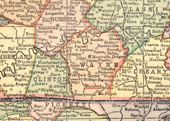
Rosa Alice Davis, wife of James Henry Smith, was born in Wayne County, Kentucky, and her parents families lived in Wayne and Clinton Counties. Many of them lived around Slickford in the southern portion of Wayne County. Rosa Alice and her family moved to Kingston, Georgia about 1911, three years before this map was made.
Wayne and Clinton Counties are located almost due north of Chattanooga on the Tennessee line.
Source of map:
http://freepages.genealogy.rootsweb.ancestry.com/~shastaca/maps/KY/KY3map.html
Wayne and Clinton Counties are located almost due north of Chattanooga on the Tennessee line.
Source of map:
http://freepages.genealogy.rootsweb.ancestry.com/~shastaca/maps/KY/KY3map.html
Lincoln and Burke Counties, North Carolina
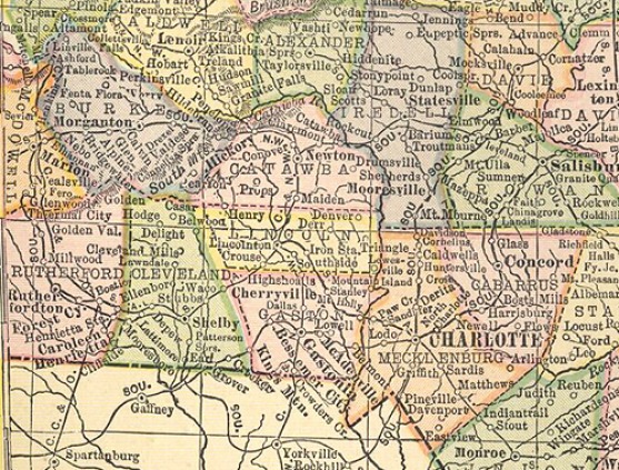
The Collins family moved to Northwest Georgia from Lincoln County, North Carolina in the 1840s. Lincoln county was formed in 1779 from the eastern part of Tryon County, and named for Benjamin Lincoln, an American Revolutionary War general.
In 1782 the southeastern part of Burke County was annexed to Lincoln County. In 1841 parts of Lincoln County and Rutherford County were combined to form Cleveland County. In 1842 the northern third of Lincoln County became Catawba County. In 1846 the southern half of what was left of Lincoln County became Gaston County.
York County, South Carolina, adjoins Gaston County.
Meanwhile, the Gipson family moved to Gilmer County, Georgia, from Burke County, North Carolina, probably right after the Cherokee Removal in 1838. Burke County is adjacent to Lincoln, although both counties were initially much larger, as the map below, from 1800, shows.

Virginia Counties circa 1770
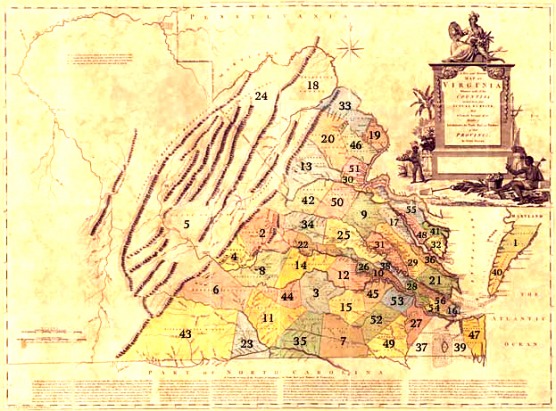
We have several families whose genealogy runs through Virginia, as could be expected. Most notable are Goochland, home of the Nowlins, and Northumberland, home of the Humphries. But we have had ancestors in many other Virginia counties as well. So I found this 1770 map of Virginia with county maps listed.
1. Accomack; 2. Albemarle; 3. Amelia; 4. Amherst; 5. Augusta; 6. Bedford; 7. Brunswick; 8. Buckingham; 9. Caroline; 10. Charles City; 11. Charlotte; 12. Chesterfield; 13. Culpepper; 14. Cumberland; 15. Dinwidie; 16. Elizabeth City 17. Essex; 18. Frederick; 19. Fairfax; 20. Fauquier; 21. Gloucester; 22. Goochland; 23. Halifax; 24. Hampshire; 25. Hanover; 26. Henrico; 27. Isle of Wight; 28. James City; 29. King and Queen; 30. King George; 31. King William; 32. Lancaster; 33. Loudon; 34. Louisa; 35. Mecklenburg; 36. Middlesex; 37. Nandsemond; 38. New Kent; 39. Norfolk; 40. Northampton; 41. Northumberland; 42. Orange; 43. Pittsylvania; 44. Prince Edward; 45. Prince George; 46. Prince William; 47. Princess Ann; 48. Richmond; 49. Southampton; 50. Spotsylvania; 51. Stafford; 52. Sussex; 53. Surry; 54. Warwick; 55. Westmoreland; 56. York
1. Accomack; 2. Albemarle; 3. Amelia; 4. Amherst; 5. Augusta; 6. Bedford; 7. Brunswick; 8. Buckingham; 9. Caroline; 10. Charles City; 11. Charlotte; 12. Chesterfield; 13. Culpepper; 14. Cumberland; 15. Dinwidie; 16. Elizabeth City 17. Essex; 18. Frederick; 19. Fairfax; 20. Fauquier; 21. Gloucester; 22. Goochland; 23. Halifax; 24. Hampshire; 25. Hanover; 26. Henrico; 27. Isle of Wight; 28. James City; 29. King and Queen; 30. King George; 31. King William; 32. Lancaster; 33. Loudon; 34. Louisa; 35. Mecklenburg; 36. Middlesex; 37. Nandsemond; 38. New Kent; 39. Norfolk; 40. Northampton; 41. Northumberland; 42. Orange; 43. Pittsylvania; 44. Prince Edward; 45. Prince George; 46. Prince William; 47. Princess Ann; 48. Richmond; 49. Southampton; 50. Spotsylvania; 51. Stafford; 52. Sussex; 53. Surry; 54. Warwick; 55. Westmoreland; 56. York
